Introduction: How Bangkok Moves
This Bangkok public transport guide is written for European travellers who like to understand a city’s layout, options and everyday routines before they arrive. It focuses on the basics of getting around the Thai capital with confidence, from elevated trains to river boats and ride-hailing.
Bangkok is a sprawling metropolis that reveals itself in layers, and understanding its transport network helps you connect neighbourhoods, choose where to stay and manage the city’s contrasts of calm and chaos. For a fuller picture of how different districts feel on the ground and how transport shapes them, you may also find it useful to explore this overview of where to stay in Bangkok for first-time visitors.
Orientation-wise, Bangkok stretches along the Chao Phraya River on Thailand’s central plains, with modern business districts to the east, the historic Old Town to the west, and a web of skytrain lines, metro tunnels and waterways tying everything together.
Understanding the Basics of Bangkok Public Transport
Bangkok’s transport system is a combination of modern rail, traditional river routes and road-based services. For most visitors, the core network consists of four main elements: the BTS Skytrain, the MRT subway, the Chao Phraya boats and app-based rides such as Grab.
The BTS and MRT form the backbone for moving efficiently through central Bangkok, largely avoiding the city’s famous traffic. The Chao Phraya boat services, running up and down the river, offer a different way of navigating Bangkok, linking the Old Town, riverside temples and newer riverfront developments. On top of this, Grab in Bangkok fills in gaps where rail lines do not reach, or when the heat or rain makes walking less comfortable.
Public transport is especially helpful for first-time visitors who want to balance comfort with curiosity. The system is not as extensive as some European capitals, but it is structured, signed in English and manageable once you understand its logic.
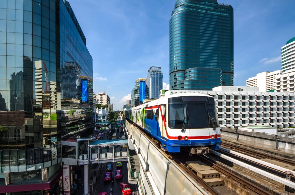
BTS Skytrain: Elevated Shortcuts Through Modern Bangkok
The BTS Skytrain is usually the easiest entry point into Bangkok’s transport network for European visitors. Operating on elevated tracks above major roads, it connects many of the city’s key commercial and shopping districts, including Sukhumvit, Silom and Siam.
From a transport basics perspective, the BTS is ideal for north–south and east–west journeys through the modern city core. Trains are air-conditioned, frequent and comparatively straightforward to navigate, with station names and announcements in English and Thai. Stations are typically linked to shopping centres, skywalks and office towers, making transfers and short walks more comfortable in the heat.
For visitors, the BTS is particularly useful if you are staying in areas like Sukhumvit or around Siam, where many major malls, dining areas and hotel clusters are within a short walk of a station. During weekday rush hours, however, expect very full trains and platforms, not unlike busy metro lines in larger European capitals.
MRT Subway: Underneath the City and Into Local Neighbourhoods
When comparing Bangkok BTS vs MRT, you are essentially comparing two complementary systems. The MRT runs mostly underground and serves a slightly different set of districts, often with a more local, residential or governmental character. It connects areas like Ratchada, the new central station complex, and parts of the city where there is no BTS line.
The MRT feels closer in spirit to a typical European metro, with deeper stations and longer escalators. It is particularly useful for reaching markets, cultural venues and new business areas that are not immediately visible from tourist maps. Some stations act as transfer points with the BTS, so understanding where these interchanges are helps you stitch the two systems into a single mental map.
For many visitors, the BTS is the primary daily tool, with the MRT used when an itinerary includes places such as the central train hub, certain night markets or newer urban developments. Both use separate ticketing systems, but buying single-journey tokens is simple, and signage is consistently bilingual.
River Travel: Chao Phraya Boats and Canal Routes
The Chao Phraya River shapes Bangkok’s history and remains a practical way of moving between the Old Town, riverside temples and modern riverfront hotels. Riding a Chao Phraya boat is both transport and gentle sightseeing: you see the city’s layers from the water while bypassing congested roads.
Services range from regular commuter boats with simple piers and a straightforward route pattern, to boats that stop at key visitor points such as temples and riverfront promenades. Index maps on the piers show which boats stop where, and pier names are announced on board. The experience can feel slightly improvised compared with European river services, but it is efficient once you understand the direction of travel and the pier codes.
Alongside the main river, Bangkok is laced with canals, or khlongs, where smaller boats operate on certain routes. These canal boats are primarily for locals and can be an interesting experience, but they demand more confidence with boarding, timing and water spray. For most first-time visitors focusing on transport basics, the main Chao Phraya boat lines between central piers are the most practical and comfortable option.
Grab in Bangkok: Filling the Gaps Between Lines and Piers
Even with trains and boats, Bangkok’s layout means there will be moments when an app-based ride is the simplest solution. Grab in Bangkok functions similarly to ride-hailing apps in Europe, with car and occasionally motorbike options visible in a single interface.
From a planning point of view, Grab is particularly useful late at night when trains are winding down, during heavy rain, or when travelling to areas that are not conveniently near a BTS or MRT station. It is also practical for journeys involving luggage, or when travelling as a small group and valuing door-to-door comfort.
Traffic in Bangkok can be dense and unpredictable, so journeys by car often take longer than the map might suggest. For that reason, many visitors combine Grab with rail: use the BTS or MRT for the main leg of the journey, then rely on Grab for the short final stretch between station and accommodation, especially in quieter residential lanes.
Everyday Navigation: Tickets, Signage and Local Rhythms
Once you are on the ground, navigating Bangkok’s public transport is mostly a matter of understanding a few simple routines. Stations for both BTS and MRT display clear system maps, with colour-coded lines and end stations marked. English signage is standard, and station staff are accustomed to helping visitors with basic directions.
Ticketing is straightforward: you buy single-journey tickets at machines or counters, choosing your destination station. While regular users often use stored-value cards, occasional visitors can easily rely on individual tokens or paper tickets. On the river, you typically pay at a small booth on the pier or directly on the boat, depending on the service.
Local rhythms matter. Weekday mornings and late afternoons see pronounced rush hours, particularly on central BTS and MRT segments. In the middle of the day and later in the evening, services feel calmer and often more comfortable for those not used to dense crowds. On the river, daylight hours are generally the most pleasant; after dark, some services reduce frequency, and smaller canals can feel very local and less structured.
Linking Transport to Neighbourhood Choice
Understanding how the BTS, MRT, boats and Grab interconnect helps you read Bangkok’s districts more clearly. Areas like Sukhumvit and Siam feel well-connected by BTS, making them convenient for visitors who plan to move around frequently by train. Silom and Sathorn benefit from both BTS and proximity to the river, appealing to travellers who enjoy a mix of business-district order and access to the Chao Phraya.
The historic Old Town on the western side of the modern core is less integrated into the rail network, relying more on river boats, buses and road travel. Here, using a combination of Chao Phraya boat services and occasional Grab rides works well for visiting temples, palaces and older neighbourhoods. This contrast between rail-connected modern districts and more traditional riverside areas is part of Bangkok’s character.
For stays of several days or longer, many visitors naturally develop their own rhythm: perhaps using BTS and MRT on sightseeing days, returning by river boat in the late afternoon for a different perspective, then relying on short Grab rides when the temperature rises or rain starts. Recognising that no single mode serves all needs, and that combining them is normal, is the key to feeling comfortable with Bangkok’s public transport network.
Practical Transport Tips for Bangkok
- Plan around the heat: Prioritise BTS, MRT and boats during the hottest hours; keep long walks between stations and sights to early morning or evening.
- Allow time at interchanges: Changing between BTS and MRT can involve long corridors, escalators and security checks, especially in large complexes.
- Mind peak hours: Avoid central BTS and MRT lines around office start and end times if you prefer quieter journeys.
- Stand on the correct side: On escalators, locals often stand on one side and walk on the other; observe the flow and follow the local pattern.
- Prepare small notes or coins: Ticket machines for BTS, MRT and boats are easier to use with smaller denominations.
- Keep your ticket handy: You will often need to insert or scan your ticket again when exiting BTS and MRT stations.
- Dress for air-conditioning: Trains and some boats can be significantly cooler than the outside temperature; a light layer can be useful.
- Watch your step on boats: Piers and deck edges can be uneven or wet; wait for staff signals when boarding or disembarking.
- Use landmarks, not only addresses: When using Grab in Bangkok, confirming a nearby landmark or known building can help drivers locate you more easily.
- Check last train times: BTS and MRT do not run late into the night; knowing the final departure helps you decide between rail and Grab.
- Follow queuing norms: On BTS platforms, stand behind marked lines and let passengers exit before boarding, as local commuters do.
- Expect bag checks: Some BTS and MRT stations perform quick security screenings; allow a little extra time.
FAQs: Using Public Transport in Bangkok
Is the BTS or MRT better for getting around central Bangkok?
The BTS is generally more useful for visitors whose activities revolve around Sukhumvit, Siam and Silom, as it runs along major commercial corridors. The MRT complements it by serving additional neighbourhoods and key hubs such as the main railway complex. In practice, using both together offers the most flexibility.
How do I use the Chao Phraya boat without knowing Thai?
Pier names and basic route information are shown in English, and staff are used to helping visitors with the correct boat. Check the direction of travel, confirm the pier you want, and pay at the pier or on board as indicated. It can feel busy, but the system is relatively straightforward once you recognise the main piers.
Is Grab in Bangkok reliable for airport or late-night journeys?
Grab is widely used in Bangkok and is a practical option for late-night or early-morning transfers, as well as journeys to areas not near rail stations. Traffic conditions can affect travel time, so plan with a margin, but the service itself is well established.
Can I rely only on public transport, or do I need taxis as well?
If you stay near a BTS or MRT station and plan your days with the network in mind, you can cover much of central Bangkok by train and boat. However, for certain neighbourhoods, late-night returns or heavy rain, supplementing public transport with Grab or regular taxis is often more comfortable.
Are Bangkok’s trains and boats suitable for families or older travellers?
BTS and MRT trains are modern, air-conditioned and manageable for families and older travellers, though crowds at peak times can be tiring. Boats on the Chao Phraya are a gentler way to travel if you board at quieter times of day and take care on the piers and steps.
Conclusion: Choosing Your Own Way Through Bangkok
Bangkok’s public transport system is a layered mix of elevated trains, underground lines, river services and app-based rides. Each mode has its strengths: the BTS and MRT bring structure and predictability, the Chao Phraya boats provide both movement and perspective along the river, and Grab fills in the inevitable gaps between rails and water.
Understanding how these elements interlock allows you to read the city more clearly and move between its modern districts, historic quarters and quieter corners with a sense of orientation. The trade-off is that no single mode covers everything; combining them thoughtfully is the simplest way to navigate Bangkok in a way that suits your own pace and preferences.
Recommended next:
- Thailand Itinerary 10 Days: Bangkok, Chiang Mai & Islands for First-Timers
- Thailand Itinerary 14 Days: Classic Route with Beaches and Northern Culture
- Thailand in 7 Days: Bangkok + One Beach Base (No Rushing)
- Best Time to Visit Thailand: Month-by-Month Weather for Europeans
- Thailand Travel Costs: Realistic Daily Budget for European Travelers
- Thailand Travel Insurance Guide: What to Cover and What to Skip
- More in Thailand →